Free Website Hosting

feature content slider

Destination

10 Famous Buddhist Temple in The World

Buddhism takes as its goal the escape from suffering and from the cycle of rebirth: the attainment of nirvana. There are between 230 million and 500 million Buddhists worldwide. An overview of the most famous Buddhist temples in the world.

Dragon Village at Tasikmalaya, West Java

If you are tired of life in a metropolitan city with its sky scrapers, you should take a few days off to stay in the Dragon village within Neglasari village, Salawu sub-district, Tasikmalaya, West Java. This 1.5 hectares village is still 'green' and not influenced by modernization..

Exotic Dieng Plateau

The name ‘dieng’ which literally translates as ‘abode of the Gods’ says all you need to know about this collection small ancient temples set in the remarkable volcanic landscape of the Dieng Plateau.

Living in the shadow of Indonesia's volcanoes

All hell is about to break loose, but Udi, a 60-year-old farmer from the village of Kinarejo on the Indonesian island of Java, will not budge. Not even though a mere three miles (five kilometers) separates the smoldering peak of Mount Merapi from Kinarejo.

National Geographic : Merapi Eruption

Nationalgeographic.com Smoke rises Monday from Indonesia's Mount Merapi, one of the world's most volatile and dangerous volcanoes.

April 29, 2010

12 countries to attend ethnic language congress in Baubau

Representatives of 12 countries have confirmed to attend an international ethnic language congress in the Southeast Sulawesi city of Baubau on July 8, 2010.

Local tourism and cultural office's archaeological service spokesman Ali Arham said Wednesday that out of 30 countries invited to attend the congress, 12 had confirmed their participation.

"They have sent their confirmation to us by email," Ali said, adding that the 12 countries included The Netherlands, Australia, the US, Brunei Darussalam, Malaysia and Papua New Guinea.

Ali said other countries expected to confirm their participation in the near future would be, among others, Germany, China, South Korea, Japan and Singapore.

He said that besides foreign participants, the congress would also be attended by a number of linguists from several universities in Indonesia.

Arham said the congress was aimed at enabling the participants to discuss various issues related to ethnic languages and literature.

The result of the congress would then be reported to the government to make a policy to preserve and develop other languages, he said.

source: the jakarta post

Hundreds to take part in Sail Indonesia

Around 220 participants from 22 countries across the world have confirmed their participation in the 10th of Sail Indonesia, which will start on July 24.

According to the annual sailing rally’s official website www.sailindonesia.net, the participants will depart from Darwin, Australia, and enter Indonesia through Kupang, the capital of East Nusa Tenggara (NTT).

Provincial tourism agency official Ubaldus Gogi told tempointeraktif.com on Tuesday the participants would visit Rote Ndao, Alor, Sikka, Nagekeo, Ende, South Central Timor and Labuan Bajo.

After spending a few days in Kupang, some the participants would take part in the Sail Banda in Maluku, while some others would visit Bali.

April 25, 2010

Enjoying Bumi Sriwijaya

by: garuda magazine
Packed with historic sites and renowned for the quality of its cuisine, Palembang’s charms are attractive indeed

Museum Sultan Mahmud Badaruddin II

Palembang, the capital of South Sumatera Province, is also known as Bumi Sriwijaya (Sriwijaya Land). In 712 AD this area was the centre of the largest and strongest maritime kingdom in Indonesia, whose influence reached as far as China in the North and Madagascar off the coast of Africa to the west.

“Nak kemano kita kak? (Where are we going now, sister?)” asked Pak Wicaksono with distinctive accent Palembang, the driver who was going to escort me on my journey around Bumi Sriwijaya.

The heavy rain that started in the early hours of the morning actually made me pretty reluctant to get moving. Because Palembang is on average only 12 metres above sea level, and with tides reaching 3 to 5 metres, several lower lying parts of the city, especially on the outskirts, are often flooded. However, I eventually decided to drive around while waiting for the rain to stop and started savouring the city which is officially the 17th Tourist Gateway in Indonesia.

Fifteen minutes out on the road and the rain eased, although the sun was still hiding behind the clouds as I arrived at Jembatan Ampera (Ampera Bridge), one of the city’s icons. It was built by Japan and was opened by President Soekarno in 1964; at that time it was the longest bridge in south east Asia.

The bridge across the River Musi is 1,177 metres long, 22 metres wide and 11.50 metres above the surface of the water. Early on it was called Musi Bridge but then in the 1970s it was renamed Ampera Bridge (the People’s Hardship Mandate).

Ampera Bridge

It used to be that the middle part of the bridge could be raised so that ships could pass underneath. However, since the 1970s, because people are more and more mobile and there are more vehicles, as well as for some technical reasons, the bascule bridge function is no longer in use.

From the bridge, I went to the area around Kuto Besak Fort which is close to the Museum of Sultan Mahmud Badaruddin and Mesjid Agung (the Great Mosque).

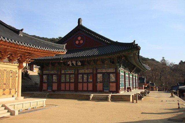
The Fort of Kuto Besak, whose walls are three metres high, was constructed by the Sultan of Palembang and it took 17 years to complete. It was built as a defence against the Dutch military who tried several times to capture Palembang. It is now used as the headquarters of Kodam II Sriwijaya (the regional military command) and Dr. A.K. Gani Hospital. This means that tourists are only able to see its exterior.

The Museum of Sultan Mahmud Badaruddin II, which faces the Musi River, is located at the northern end of Ampera Bridge. It was built by the Dutch authorities in 1823 on the site of the Sultan of Palembang’s palace which was destroyed when the Dutch attacked. The museum building, which is a combination of traditional Malay and Dutch colonial architecture, was used as a residence by Dutch officials. This museum has a collection of historical and cultural artefacts from Palembang.

Not far from the museum and the fort, the Great Mosque stands imposingly on the corner of Jl. Jenderal Sudirman and Jl. Merdeka. This mosque is one of the legacies of the Palembang Sultanate and was built by Sultan Mahmud Badaruddin I in 1740. The area in the vicinity of the mosque used to be the capital of the Islamic Kingdom of Palembang.

Masjid Agung Palembang

The tourists flock to the area around Kuto Besak Fort morn, noon and night. Many of them come here to appreciate the picturesque views with Ampera Bridge and the Musi River in the background. What is more, we can also rent a boat and cruise down what is often referred to as the river tourist town.

At night the area promises different charms: the sparkling lights that decorate Ampera Bridge; floating coffee shops offering the sensations of coffee and Palembang specialty snacks, such as pempek, amidst the rhythms and cadence of street musicians and the rocking motion of the Musi River’s ripples.

If the weather is inclement, the most interesting and tantalising tourist activity in Palembang is related to its delicious cuisine.

In almost every corner of Palembang we can find mobile food sellers on their bicycles or motorbikes, and foodstalls and restaurants along the streets, all offering Pelembang’s famous snack.

Pempek is well known and closely identified with Palembang. It is a kind of dumpling made from fish and tapioca flour, served with a thin sauce called cuko made from white sugar, garlic, table vinegar and chillies. It is said to be a dish with some foreign influence and has been in existence since the 16th Century when Sultan Mahmud Badaruddin II reigned in the Kingdom of Sriwijaya. An old Chinese man, so the story goes, thought it such a pity that the abundance of fish caught in the Musi River was not being put to good use. They only fried and salted them. After a bit of experimentation, the old man was finally successful and came up with a new snack and hawked it around town on his bicycle. People wanting to buy some called out to him: “Apek! Apek!” (meaning “old” in Chinese). Over the course of time, the food became known as empek-empek before finally changing to pempek.

Pempek, mie celor and biriyani rice, delicious cuisine from  Palembang

Apart from pempek, Palembang boasts other specialties with fish as their main ingredient such as model, tekwan and Palembang crackers, also known as kemplang, consisting of fried, grilled kemplang and kerupuk. Several other localities in South Sumatra, like Ogan Ilir and Ogan Komering Ilir, are well know for their salted fish and smoked fish. And another area is known for its Pindang.

Another kind of food that is no less delicious is celor noodle in Rumah Makan 26 Jl. Ilir HM Syafei. During holidays this smallish restaurant may sell as many as 1,000 portions of celor noodles in a day. The secret of its tastiness is way that the flavour of shrimp is allowed to dominate the other ingredients. The noodles are the yellow egg kind but, while egg noodles are usually curly, these are much bigger and straight rather like spaghetti. Those who have not tried celor noodle before may well think it is a variant of the famous Italian pasta.

It was still pouring when I arrived at No. 30 Jl. Kiranggo Wirosentiko, Ilir, Palembang. Along this street there are a lot of craftspeople producing woven cloth called songket and several songket boutiques. Palembang’s songket, both in the form of broadcloth and scarves, is nowadays well known all over Indonesia, especially after it being heavily promoted at various events, festivals and exhibitions.

Songket is a traditional craft native to Palembang, using silk combined with golden threads woven with a high degree of artistry. It is a cottage industry and normally carried out by women.

Songket, which is usually quite expensive, utilizes various motifs such as lepus, jando beraes, bunga inten, tretes midar, pulir biru, kembang suku hijau, bungo cino, bunga pacik and others. Women usually wear them for weddings, formal parties and traditional ceremonies.

One of the boutiques that travellers often visit is Fikri Collection, which sells different kinds of songket with both traditional and the most up-to-date designs. There are about 20 craftspeople employed there and we can see them at work. There are about 50 others who carry out their craft and work from home. The price varies from Rp. 600,000 to several million rupiah, depending on the type of material and the motif.

Besides visiting the weaving district on Jl. Kiranggo Wirosentiko, I also went to Kampoeng BNI Tenun Songket in Muara Penimbung Village, Indralaya, in the Regency of Ogan Ilir, South Sumatera. The weaving kampong that lies about 35 kilometres from Palembang was inaugurated by the Coordinating Minister of Economics, Hatta Rajasa, last February.

Songket in the weaving process.The Songket Weaving Village was developed by BNI to produce songket cloth. This cottage industry so far has not been able to reach optimal production nor have the villagers prospered. In BNI’s programme, called PKBL (Program Kerja Bina Lingkungan or Environment Building Work Programme), the craftspeople receive training, consultation, capital and help with marketing.

Like other big cities in Indonesia, the traffic in Palembang is heavy. In order to provide its people with decent, safe and inexpensive public transport, the local authorities are planning to launch a bus service called “Trans-Musi” to replace the current bus routes. However, those old buses are certainly interesting with pictures covering almost the entire windscreen!

The last ten years in Palembang have seen a lot of changes. The common impression that a trip there will not be comfortable one has changed. Now it is safe and pleasant, and the clean up continues as it prepares itself to become the host and venue for the SEA GAMES XXVI next year.

Getting to Palembang:
Garuda Indonesia has 49 flights on the Jakarta-Palembang vv route every week.

April 15, 2010

Pangandaran Beach

Pangandaran is a small town and a subdistrict in southern Ciamis regency, West Java, Indonesia. It is located on the southern coast of Java. Pangandaran is a popular tourist destination, having a beach which is considered to be one of the finest in Java and which offers excellent surfing.

A kite-flying festival is held on the beach in July and August. It is reported that the locals used to fly kites in the evenings to catch bats, and may still do so. There is a local belief that wearing any green garment in this area will anger Loro Kidul, the Javanese guardian spirit or goddess of the southern sea, and will bring misfortune.

The Penanjung Pangandaran nature reserve is nearby on a peninsula connected to the mainland by a narrow neck of land. About eighty percent of the nature reserve is secondary rainforest. The flora of the nature reserve includes the Rafflesia.

A tsunami hit the area on 17 July 2006. An undersea earthquake measured at 7.7 on the Richter scale triggered a three metre high tidal wave. Extensive damage was caused and hundreds of people were reported to be dead or missing

Pangandaran is a Tourist Location in West Java, Indonesia. Pangandaran is Family friendly and has also for individual Tourists much to offer. In the Bay Area Pananjung are two beautiful Beaches for swimming, surfing or just relaxing. Here you have much Activities and Adventures like Trekking, Snorkeling, Fishing and many more..

The National Park
On the southside From Pangandaran is a National Park mostly as Jungle. You can Walk there with a Guide to the beautiful Waterfalls and enjoy the flora and fauna. Or by a 1 day Trip around the Park

Batu Karas
Batu Karas is a little Village 1 hour away from Pangandaran. It's famous for Surfing there.

Batu Hiu
Batu Hiu is a Place between Pangandaran and Batu Karas. Batu Hiu means Shark's Rock wich is a coastal rock having the shape of a shark. It's nice for relaxing there or swimming at the Beach.

Green Canyon
The best Way to go to the Green Canyon is with a Guide or by Rent a Motorbyke. At a Boat Station are many Boats who drive to the Green Canyon. After 45 Minutes Boat drive over a nice River you are there. There is also the chance to swimming in the Green Canyon.

Getting Here
Pangandaran is locatet at the Southcoast from West Java, Indonesia in the District Ciamis. See the Descriptions above and the Map for further Information.

From Jakarta
A fast Way from Jakarta is by bus. The buses drive nearly every hour from Kampung Rambutan bus station toward Pangandaran. Most buses drive directly to Pangandaran. With some buses you have to change the bus in Ciamis or Banjar. The trip lasts around 7 hours and cost around Rp.50'000 without AC and around Rp.80'000 with AC. The fee depends on the bus company.

It's also possible to rent a Car with a Driver in Jakarta. This will cost around Rp.1'500'000.

From Bandung
With the bus you reach Pangandaran on the bus station Cicaheum. Some buses drive directly to Pangandaran. With some buses you have to change the bus in Ciamis or Banjar. It's recommendable to take a bus who drive direct to Pangandaran. The buses from Banjar are small and mostly overcrowded.

April 11, 2010

Maluku, the beautiful archipelago from east of Indonesia

Maluku (Moluccas), a region of Indonesia formerly known as the Spice Islands, was once the source of cloves and nutmeg, spices highly valued for their aroma, preservative ability, and use in medicine before people learned how to cultivate the plants in other parts of the world. Maluku is a cluster of about one thousand islands totaling 74,504 square kilometers, forming part of the Malay Archipelago in eastern Indonesia near New Guinea. The region is divided into two provinces, Maluku with its capital in Ambon, and North Maluku (2002 estimated population 913,000), with its capital in Ternate; other important islands in the group include Halmahera, Seram, and Buru.

Its approximately 1000 islands support a population of less than 1.7 million people. The average population density figure is 19 people per-square kilometer, but the distribution is uneven. Air and sea transportation is the main means, which link the islands together. The province has 32 seaports and 20 airports, and only about 160 km of roads. However, good roads on many of the islands provide easy access to the often-remote places of tourists' interest.
Maluku lies in the transition zone between Asiatic and Australian flora and fauna and has a tropical climate. Maluku's flora includes meranti trees and many kinds of orchids; distinctive fauna includes cuscuses, birds of paradise, wild goats, and parrots. The economy is based on subsistence agriculture, especially sago (the sago palm, producing a starch used in food), and on the export of such products as spices, cacao, coffee, coconuts, fish, and minerals. Important indigenous groups include the Ambonese.

A great variety of endemic plant and animal species are found in the rugged forest-covered and mountainous hinterlands of most of the islands. A few of the best known are the Rucker-tailed kingfisher, the red-crested Moluccan cockatoo, and various brilliantly colored lorikeets and parrots. Most of Maluku sits astride one of the world's most volatile volcanic belts.

GEOGRAPHICALLY
Maluku province with its capital Ambon, stay at 30 north latitudes 8,300 south latitudes and 1250 - 1350 east longitudes with the area boundaries:
North side: North Maluku Province
South side: Timor Leste and Australia
West Side: Southeast Sulawesi and Central Sulawesi
East Side: Irian Jaya Province

THE WIDE AREA
The wide area of Maluku province is 712.479,69 km_, with the land wide is 54.185km_ and sea wide is 658.294,69km_.
The Maluku Province plain is 85.728 km2 width or 8.572.800 Ha contain of 3 part that is:
- Flat Land: 1.251.630 Ha width (14,6%)
- Wavy Land: 2.417.530 Ha width (28,2%)
- Hilly and Mountainous Land: 4.903.640 Ha width (57,2%)
Almost, Maluku has no upland. The mountain is a back that spread in the middle of the island, forming the mountain with the highest of 3.055 m.

TOPOGRAPHY
Maluku province consists of mountains, islands that spread from west to east and form north to south among 1150 km.

GOVERNMENT ADMINISTRATION AREA
Administratively, Maluku Province divided into four regencies and one city that is:
1. Central Maluku regency with 15 districts, 296 villages and 6 sub-districts.
2. Southeast Maluku regency with 8 districts, 229 villages and 6 sub-districts.
3. West-Southeast Maluku regency with 5 districts, 187 villages and 1 sub-district.
4. Buru regency with 3 districts, 62 villages.
5. Ambon city with 3 districts, 30 villages and 20 sub-districts.

CLIMATE
Maluku has 2 seasons, that is: west season or north, and southeast or east. West season in Maluku is come from December until March, while April is transition season to southeast season. Southeast season is average 6 months begin from May and end on October. The transition to West season is on November.
The homogenate seasons are give different affect to the land and its sea in this region. The temperature is about 26,2 C (in Southeast Maluku especially in rainy).

April 9, 2010

Wonderful Nias Island

Nias Island lies about 125 km of west Sumatra Island on the Indian Ocean. It is part of North Sumatra Province. The water surround the island is great for sea activities, such as surfing and scuba diving. The people also have curious culture, which will enrich visitor's heart. The island has some prehistoric remains, which built on megalithic Stone Age, and considered came from the oldest megalithic culture in Indonesia.

The local call their land as Tano Niha or "land of the People", while the people calls them selves as Ono Noha. Ethnically, the Niasers are involved in to the Ptoto-Malay ethnic who once ever get with the Asian Proto-mongoloid world. Niasers speak a kind of language related to Malagasy. Because of the similarity in languages, custom, body size of the Niasers with the Bataks on Sumatra mainland, it is possible that the Niasers have derived from the Bataks.
Surfers will call this island "Paradise on Earth". Together with its beautiful white sandy beach, Lagundri Bay challenge surfers with spectacular waves. In the high season, the waves told to be as high as 3.5 meters. The waves of Sorake Beach on Lagundri Bay have ranked to be within the best ten waves of the world. It is true if some surfers referred of Sorake Beach waves as "the most notorious right-band reef breaks". There are events held for surfers, including the World Professionals Qualifying Series. Surfers are better being ready when your heart cannot leave this island after a visit.

Enormous breakers pummel of Nias Island attracting the best surfers in the world to Lagundri Beach. The unforgiving power attacking the shore seems to have bred the same qualities in the people, whose militaristic culture has fascinated anthropologists for decades. This island lies off West Sumatra in the Indian Ocean. Bawomataluo and Hilisimae villages are curious places to visit, where visitors can see performances of traditional war dances and thrilling high- jump sports, i.e. people making dangerous leaps over 2 meter-high stones. Typical scenes are dancers clad in traditional costumes with bird feathers on their heads, a hall for the Chief-of Tribe built on wooden logs with stone chairs weighing up to 18 tons. There are daily flights from Medan to Nias Island.

To reach this place, there is weekly ship from Jakarta (the capital city of Indonesia) to Gunung Sitoli; There are Ferries from Sibolga to Gunung Sitoli, Teluk Dalam, or Lahewa every day; Before the crisis hit Indonesia, there is daily flight from Medan to Gunung Sitoli, however it is less frequent nowadays. Gunung Sitoli is the capital city of Nias and it is the center of administration and business affairs of regency. There are several travel agencies hotels, public busses and rental cars to support tourism here. There are also some government and private banks available.

Geographically
Nias Island lies on 10 30' north latitude and 970 98' east longitudes. It covers of 5,625 km2 areas, which is mostly lowland area of ± 800 m above sea level.

Population
It is the biggest in a group of islands on Sumatra side that is part of North Sumatra province. This area consists of 131 islands and Nias Island is the biggest. The population in this area is about 639,675 people (including Malay, Batak, and Chinese). Nias has a very unique culture and nature, which is far different from other areas in North Sumatra. This is because of its separate and remote location from the rest of Sumatra.

Unique Tradition
The many stone sculptures, from uncarved blocks to fine relieves and figures, are witness to festivals of merit or passage. In the southern villages, whole groups of obeliscs, benches, tables and seats can be situated in front of a house. In Central Nias, groups of horizontal sculptures, called behu, are found. They can be plain obelisks or anthropomorphic figures.

Segments of stone walls are the main objetcs of a ritual in South Nias villages: the lompat batu, jumping over the stone.

How to Get There

By plane

A large number of international airlines fly to Indonesia's capital, Jakarta, from where several domestic airlines fly to North Sumatra's capital, Medan. There are also direct flights to Medan from Singapore and Kuala Lumpur, Malaysia. It takes a 45 minutes flight to reach Nias from Polonia Airport, Medan.

Merpati Airlines (20 seats) and Riau Airline (50 seats) operate twice daily flights to the Binaka Airport in Gunungsitoli, which is located in the northern part of the island. It is here where your journey to discover the southern part of the island will start! Bookings can be made directly with these airlines or with any travel agent.

Please reconfirm your return flight 48 hours before your departure from Nias to ensure seat availability on the day you are due to leave.

From Binaka Airport to Sorake Beach

From Binaka it takes 2.5 hours by car to reach the Sorake Beach area in the Teluk Dalam sub-district, South Nias. To make your travel more comfortable and spare your surf board from damages, you can arrange a car in advance through your travel agent or guide to pick you up at the airport..

For those who have not rented a car in advance, it is also possible to rent a car upon your arrival at the airport. Several rental car owners offer their services at the airport.. They charge around Rp 500,000 for bringing you to southern Nias. (Rate in 2008)

Alternatively, you can take a minibus, which is much cheaper. There are minibus services (operated by Sabang Merauke Air Charter and Riau Airlines) from Bineka Airpot to Gunungsitoli (Rp 35,000). The bus terminal is located around 1.5 km south of the center of Gunungsitoli from where minibuses go to Teluk Dalam. The three-hour drive will cost you around Rp 60,000. From Teluk Dalam, you can take a local bus to Sorake Beach for Rp 6,000. But if you want to enjoy fresh air while travelling, you can take a motorbike-taxi (ojek), which costs around Rp 20,000.

By Ferry

To experience a more local and challenging way of travelling, you can travel over land to from the Sibolga Seaport in North Sumatra, wher you can take a ferry to Nias Island. When the sea is calm, the ferry trip to Gunung Sitoli port takes round nine hours and around 12 hours to Teluk Dalam.

Car and motorcycle rental

Public transportation in South Nias is not readily available. Pick-up transportation service is common in which a car takes passengers from one village to another. It is also possible to rent a car or motorcycle in Teluk Dalam or the Sorake beach area. The car rental rate is around Rp 500.000 per day, including gasoline and driver, rental rate for a motorcycle is around Rp 200.000. If you ride a motorcycle, please don't forget to wear a helmet for your own safety.

April 2, 2010

Quite, Peaceful Amed

By Garuda Indonesia Magazine

Few places in Bali allow you to enjoy a simple coconut oil massage while lying on a bamboo bed in the shade of a fishermen’s hut as Amed.

Tourists are keen to hire traditional boats to explore the bay.

The Bali that was, long-time Bali-based expat residents insist, can still be found lying a two-hour leisurely drive from Kuta.

A calm and peaceful place, Amed has in recent times rose to discrete prominence, a much-deserved status arrested in the past by bad roads and lack of power and communications, which actually complements its irresistible quietness.

Every bay, some sandy, others rocky, appears to be lined with double-outrigger traditional fishing boats (jukung).

The horizon almost invariably is rife with literally hundreds of the boats’ colorful triangular sails heading off to the fishing grounds morning and afternoon.

Amed is a near-perfect destination for the more mature (read: above 50 years of age) travelers though younger people like it too as it offers them a daily fix of peace and tranquility.
The locals lead a quite lifestyle, making Amed an ideal place for you to spend time either writing your bio, taking stock of your life or doing just nothing and relax.

This relatively undeveloped north-eastern coastal strip in the Karangasem Regency of East Bali, where Amed is located, features some of the island’s best snorkeling amidst spectacular sunrises over the neighboring island of Lombok.

On any given time you are apt to come across tourists strolling slowly along the road or the beach. Or elderly couples walking holding hands, rekindling their love for each other in their own special way, Amed-style.

Traditional boats languishing on the beach.

And almost everywhere there you can hop on a traditional fishing boat for a sunset tour, again to reignite the proverbial fire that simmers inside you.

Amed is actually not just one village but a string of smaller villages, starting with the village Amed in the north followed by Congkang, Jemeluk, Bunutan, Lipah, Selang, Banyuning and ending with Aas.

At present Amed is mostly a quiet place with stunning ocean vistas as well as one of the best places in Bali for scuba diving.

The landscape comprises a series of headlands overlooking bays, lined with fishing boats.
From the top of the hill, one cannot but marvel at the serene scenery and feel grateful that the long tracts of land have no given way to tacky opulence in the way of star-rated hotels.

Located on the dry side of the mountains Agung and Saraya, Amed is short in rain throughout the year. The landscape is very arid and the slopes of the mountain look bare.
The sleepy village still remains untouched by the effects of tourism, but as developments, albeit at a snail’s pace, take place along this strip, Amed is likely to become one of the island’s major tourist areas, a gain for local people in search of a decent livelihood but a pain to advocates of the environment.

In the meantime, many locals subsist by producing salt thanks to their proximity to the sea.
To reach Amed is an exhausting trip but is an experience in itself: it is rich in curves and very steep ups-and-downs.

From Amed the road south via Jemeluk, Lipah, Bunutan and Selang is narrow but moderately paved, offering stunning views of mountains on one side and the Lombok Strait on the other.

Locals eke out a living by making salt.

“Jemuluk, which is a protected bay, is an ideal place to begin snorkeling. Four kilometres further south along the coast is Banyuning, where there’s a small Japanese wreck and beautiful coral gardens,” said our driver.

“The corals are alive and beautiful, but you have to travel a couple of meters to find the most vivid colors.”

Diving schools are available in the area, and readily point you out the best dive spots.
Snorkeling and diving off the black-sand beaches here is exceptional for the variety and numbers of fish. But just to be anywhere along the coast or sit in one of the seaside restaurants and observe dolphins playing in the waves is just as enthralling.

To fly from Jakarta to Bali in a 90-minute journey only to settle down in undeveloped Amed might be an uncool thing to do—it is even more uncool if you’re there and cannot manage to visit the site even for a few hours.

Getting to Amed:
Garuda Indonesia flies the Jakarta-Denpasar vv route 50 times per week, Denpasar-Mataram vv route 7 times per week, Jakarta-Denpasar-Kupang vv route 7 times per week, Yogyakarta-Denpasar vv route 14 times per week, Surabaya-Denpasar vv route 21 times per week.

To get to Amed from Kuta, head for the Bypass towards Sanur and exit to take the road on your right that leads into the coastal highway heading east.

The coastal road was completed a couple of years ago; it now allows you to drive all the way from Tirtagangga in a clockwise manner.

April 1, 2010

The Baduy Tribe


Baduy Tribe in Banten. Who is baduy tribe and how their life with no modern technology? see on Exploring Indonesia

Tanjung Puting National Park

Tanjung Puting is one of the natural wonders of the world! You may not believe this after you have been there only one day or two days or three days, but after the fourth or fifth day something happens. You are captivated completely by the purity of the air, the openness of the night sky with the most remarkable view of the Milky Way, the magnificence and dignity of the gentle orangutans, the thundering downpours that instantly cool the air, and the clarity of the brilliant crimson sunsets. Tanjung Puting is the largest and most diverse protected example of extensive coastal tropical heath and peat swamp forest which used to cover much of southern Borneo. The area was originally declared as a game reserve in 1935 and a National Park in 1982. While the Park has checkered history of weak protection, nonetheless, it remains substantially wild and natural.

Tanjung Puting is covered by a complex mosaic of diverse lowland habitats. It contains 3,040 sq km2 of low lying swampy terrain punctuated by blackwater rivers which flow into the Java Sea. At the mouth of these rivers and along the sea coast are found Nipa/mangrove swamps. Mangroves teem with animal life. Tanjung Puting also includes tall dry ground tropical rain forest, primarily tropical heath forest, with a canopy of 40 meters (120 feet) with "emergent" exceeding 50 meters (150 ft) in height, seasonally inundated peat swamp forest with peat in layers two meters deep, open depression lakes formed by fire, and open areas of abandoned dry rice fields now covered with elephant grass and ferns. The tropical heath forest which is called "kerangas" in parts of Borneo, is only found on very poor, typically white-sandy soils and is characterized by medium-sized trees.

The best known animals in Tanjung Puting are the orangutans, made famous through the efforts of Orangutan Research and Conservation Program, which is based at the landmark Camp Leakey research station. Tanjung Puting also boasts the bizarre looking proboscis monkey with its "Jimmy Durante" nose as well as seven other primate species. Clouded leopards, civets, and Malaysian sun bears cavort in the park as do mouse deer, barking deer, sambar deer, and the wild cattle known as banteng. Tanjung Puting hosts over 220 species of birds, includinag hornbills, deep forest birds and many wetland species. Tanjung Puting is well known for its "bird lakes, " seasonal rookeries for a half a dozen species of endangered water birds, including the only known Bornean nesting grounds for white egrets. Tanjung Puting also has two species of crocodiles, dozens of snakes and frogs, numerous threatened species, including the fortune-bringing and highly endangered "dragon" fish also known as the Arwana (bony-tongue). Among the most flamboyant of these animals are the many species of colorful birds, butterflies, and moths found in the Park.

How to get to Tanjung Puting
Entering to Tanjung Puting National Park,Home of rainforest animals on arrival at the pangkalan bun airport. Tanjung Puting National Park located at both region, Kotawaringin Barat known which is Pangkalan Bun as capital city and Kotawaringin Timur with Sampit as the capital city.

Pangkalan Bun part of Tanjung puting is the only part of the areas for tourist destination. How to get Pangkalan Bun???
Pangkalan Bun is devoloped city, the oilpalm agriculture as the main econimic targeting as before wood industry take 75% of the econimic. To get here is not difficult, all type of transportation are provided, air, sea and land.

From the air : There are two different airline serve everyday, TRIGANA, KAL STAR and DERAYA. They fly to most main destination in java and between Kalimantan it self. Semarang, Surabaya, Jakarta, Bandung even Denpasar. For Bandung, Jakarta and Denpasar is connecting flight.
Flight between Kalimantan serve also everyday to Pontianak, Banjarmasin and Balikpapan, you could get connecting flight to Jakarta, Denpasar, Ujungpandang and other flight destination in Indonesia even the have international flight as well.

From the sea : 4 time in week the Pelni and Ferry serve from and to Semarang or Surabaya, This is an other cheap alternative way to visist Orangutan. It will take between 18 until 23 hours cruising but they provide different class to choose for, also music entertaiment, cafe etc.

By the Road : You could take bus from Banjarmasin to Pangkalan Bun, transit at Palangkaraya and Sampit. it take 18 hours ride with really bad road at few spot. If you have sense of OFF ROAD this is the best way to take.

When you get Pangkalan Bun
There are saveral good hotel in Pangkalan Bun and many of them over inexpensive price if you want spend a night at Pangkalan Bun or You can go directly to Kumai boat stage but before that have to arrange police permit and National Park entrance permit at Pangkalan Bun. Take only 20 minutes from Pangkalan Bun to Kumai where you will rent for the traditional wooden boat or KLOTOK that will take you to the park to visit our encester ORANGUTAN.

relaxing on the boatOranghutanTours could arrange all of them easily, from your first step entering Indonesia until meet Orangutan then say good bye and arrange next destination, you will be on the first hand service. Please contact us should you need more information about Orangutan tour or Borneo adventure tour packages or other destination , day to day itinerary, special price, special request. We will be very happy to help you orgganized your tours during in Indonesia " Free of Charge

Twitter Delicious Facebook Digg Stumbleupon Favorites More